UN gives Mexico legal certainty over its rights to the Gulf seabed
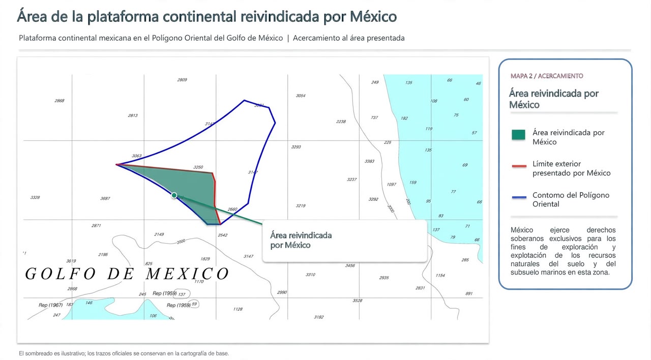
The UN Commission on the Limits of the Continental Shelf accepted the outer limits proposed by Mexico for its extended continental shelf in the Eastern Polygon of the Gulf of Mexico, a decision that provides legal certainty about the scope of the country's rights over the natural resources of the seabed and subsoil, the Ministry of Foreign Affairs (Secretaría de Relaciones Exteriores) reported.
The determination concerns the seabed and the layers beneath it, not the waters of the Gulf.
The UN Convention on the Law of the Sea recognizes sovereign rights to explore and exploit the natural resources of the continental shelf, but distinguishes that space from the water column above the seabed.
The commission is a technical body established by the Convention to examine the scientific information that countries submit when they seek to establish the outer limits of their continental shelf beyond 200 nautical miles. Its role is to evaluate that data and issue recommendations, in accordance with Article 76 of the treaty.
Mexico filed its initial submission with the commission in December 2011 and delivered supplementary information in June 2025. According to the UN record, the recommendations on the Eastern Polygon were adopted on July 16, 2026; the corresponding summary was published on November 10.
The Foreign Ministry reported that the accepted limits respect the maritime delimitations Mexico had already negotiated with the United States and Cuba for that area. The decision therefore establishes the outer extent of Mexico's continental shelf but does not alter the maritime boundaries agreed with those countries.
Under the Convention, the limits a State establishes on the basis of the commission's recommendations are final and binding. The summary of the recommendations on Mexico's submission can be consulted on the UN website.
The next step will be for Mexico to deposit with the UN Secretary-General the charts and geodetic data that permanently describe those limits, so that they are published internationally, as the Convention provides.
The Ministry of Foreign Affairs noted that the information will serve to place the outer line of the continental shelf on official record.
The Foreign Ministry attributed the outcome to technical, scientific, legal and diplomatic work coordinated by its Legal Adviser's Office, with the support of the National Institute of Statistics and Geography, the Secretariat of the Navy, the Mexican Geological Service and Petróleos Mexicanos.
More from Environment
All stories →
EU and Mexico strengthen cooperation in clean energy and circular economy
This Tuesday, the European Commissioner for International Partnerships Jozef Síkela will visit Mexico to strengthen cooperation in clean energy, sustainable transportation, circular economy and green finance.

Mexico Advances Sustainable Solutions to Confront the Water Crisis in the Sierra de Guadalupe
Amid the growing water crisis that threatens millions of people across the country, the Sierra de Guadalupe, located north of the Valley of Mexico, stands out as an example of how collaboration between the private sector and civil society can provide concrete responses.
Sheinbaum Honored for Leadership in Water Policy
Mexican President Claudia Sheinbaum Pardo has been granted the Award Recipients prize by the Water Environment Federation (WEF). The award is an international